

Prof. Itamar Lensky
CV
EDUCATION
1991 B.Sc. Physics, Magna Cum Laude Hebrew University of Jerusalem, Israel (HUJI)
1994 M.Sc. Atmospheric Sciences, Summa Cum Laude HUJI
2004 Ph.D. Atmospheric Sciences, HUJI
ACADEMIC AFFILIATIONS/APPOINTMENTS
1994 Research Assistant, Center for Climate System Research, Tokyo University, Japan
1996 Teaching Assistant, Dept. Atmospheric Sciences, HUJI
2003 Research Associate, Dept. Atmospheric Sciences, HUJI
2004 Instructor, Dept. Geography and Environment, Bar-Ilan University, Ramat-Gan, Israel (BIU)
2006 Lecturer, Dept. Geography and Environment, BIU
2011 Senior Lecturer, Dept. Geography and Environment, BIU
2014 Associate Prof., Dept. Geography and Environment, BIU
2016 Chair, Dept. Geography and Environment
Specialization fields
|
1. Cloud microphysics, cloud-aerosols interactions |
|
2. Satellite remote sensing in agriculture |
|
3. Remote sensing of the Dead Sea surface – skin temperature and suspended matter |
|
4. Remote sensing and epidemiology |
|
5. The effect of atmospheric processes of different scales on land surface temperature |
|
6. Time series analysis of satellite data |
Publications
2022
65. Michael Y., G. Kozokaro, S. Brenner, and I. M. Lensky, 2022: Improving WRF-Fire Wildfire Simulation Accuracy Using SAR and Time Series of Satellite-Based Vegetation Indices. Remote Sensing, 14(12), 2941; https://doi.org/10.3390/rs14122941
64. Kayyal-Tarabeia, I., Y. Michael, I. M., Lensky, M., Blank, K., Agay-Shay, 2022: Residential greenness and site-specific cancer: A registry based cohort of 144,427 participants with a 21-years of follow-up, Tel-Aviv district, Israel. Environmental Research. doi:10.1016/j.envres.2022.113460
63. Augustinus, B. A., M. Blum, S. Citterio, R., Gentili, D., Helman, D., Nestel, U., Schaffner, H., Müller-Schärer, and I. M. Lensky, 2022: Ground-truthing predictions of a demographic model driven by land surface temperatures with a weed biocontrol cage experiment. Ecological Modeling. 446, 109897. doi:10.1016/j.ecolmodel.2022.109897
62. Liu H., H. Yin, F. Kong, A. Middel, X. Zheng, J. Huang, T sun, D. Wang, and I. M. Lensky, 2022: Change of nutrients, microorganisms, and physical properties of exposed extensive green roof substrate. Science of the Total Environment. 805, 150344. doi:10.1016/j.scitotenv.2021.150344
2021
61. Basagaña X., Y. Michael, I. M. Lensky, L. Rubin, I. Grotto, E. Vadislavsky, Y. Levi, E. Amitai, K. Agay-Shay, 2021: Identifying windows of susceptibility during pregnancy: associations between low and high ambient temperature and birthweight for 624,940 singleton term livebirths births born in Israel during 2010-2014. Environmental Health Perspectives. 129(10), doi:10.1289/EHP8117
60. Bonfil, D.J., Y. Michael, S. Shiff, I. M. Lensky, 2021: Optimizing Top Dresseing Nitrogen Fertilization Using VENμS and Sentinel-2 L1 Data. Remote Sensing. 13, 3934. https://doi.org/10.3390/rs13193934
59. Shiff S., I. M. Lensky, and D. Bonfil, 2021: Using Satellite Data to Optimize Wheat Yield and Quality under Climate Change. Remote Sensing. 13, 2049. https://doi.org/10.3390/rs13112049
58. Elbaz S., E. Sheffer, I. M. Lensky, N. Levin, 2021: The Impacts of Spatial Resolution, Viewing Angle, and Spectral Vegetation Indices on the Quantification of Woody Mediterranean Species Seasonality Using Remote Sensing. Remote Sensing. 13, 1958. https://doi.org/ 10.3390/rs13101958
57. Zheng X., F. Kong, H. Yin, A. Middel, H. Liu, D. Wang, T. Sun, I. Lensky, 2021: Outdoor thermal performance of green roofs across multiple time scales: A case study in subtropical China. Sustainable Cities and Society, doi:10.1016/j.scs.2021.102909.
56. Shiff S., D. Helman, and I. M. Lensky, 2021: Worldwide continuous gap-filled MODIS land surface temperature dataset. Scientific Data. 8:74. doi:10.1038/s41597-021-00861-7.
55. Michael Y., D. Helman, O. Glickman, D. Gabay, S. Brenner, and I. M. Lensky, 2021: Forecasting fire risk with machine learning and dynamic information derived from satellite vegetation index time-series. Science of the Total Environment. doi:10.1016/j.scitotenv.2020.142844
2020
54. Bodenheimer S., R. Nirel, I. M. Lensky, and U. Dayan, 2020: The Synoptic Skill of AOD and Angstrom Exponent Levels over the Mediterranean Basin. International Journal of Climatology. doi:10.1002/joc.6931
53. Dayan U., I. M. Lensky, B. Ziv, and Khain P., 2021: Atmospheric conditions leading to an exceptional fatal flash flood in the Negev Desert, Israel, Nat. Hazards Earth Syst. Sci., 21, 1583–1597, https://doi.org/10.5194/nhess-21-1583-2021
52. Grodek T., E. Morin, D. Helman, I. Lensky, O. Dahan, M. Seely, G. Benito, and Y. Enzel, 2020: Eco-hydrology and geomorphology of the largest floods along the hyperarid Kuiseb River, Namibia. Journal of Hydrology. 582, 124450. doi:10.1016/j.jhydrol.2019.124450
2019
51. Bodenheimer S., I. M. Lensky, and U. Dayan, 2019: Characterization of Eastern Mediterranean dust storms by area of origin; North Africa vs. Arabian Peninsula. Atmospheric Environment. 198, 158-165. doi:10.1016/j.atmosenv.2018.10.034
50. Helman D., I. M. Lensky, and D. J. Bonfil, 2019: Early prediction of wheat grain yield production from root-zone soil water content at heading using Crop RS-Met. Field Crops Research . 232,11-23. doi:10.1016/j.fcr.2018.12.003
49. Helman D., D. J. Bonfil, and I. M. Lensky, 2019: Crop RS-Met: A biophysical evapotranspiration and root-zone soil water content model for crops based on proximal sensing and meteorological data. Agricultural Water Management. 211, 210-219. doi:10.1016/J.AGWAT.2018.09.043
48. Agay-Shay K., Y. Michael, X. Basagana, E. Martinez, D. Broday, I. M. Lensky, M. Rudolf, L. Rubin, R. Kent, N. Levy, Z. Haklai, and I. Grotto. 2018: Mean and variance of greenness and pregnancy outcomes in Tel Aviv during 2000–14: longitudinal and cross-sectional approaches. International Journal of Epidemiology. 48(4) 1054-1072, https://doi.org/10.1093/ije/dyy249
2018
47. Lensky I. M., U. Dayan, and D. Helman, 2018: Synoptic circulation impact on the near surface temperature difference outweighs that of the seasonal signal in the Eastern Mediterranean. Journal of Geophysical Research-Atmospheres, 123, 11333-11347. doi:10.1029/2017JD027973
46. Michael Y., Lensky I.M., Brenner S., Tchetchik A., Tessler N., Helman D., 2018: Economic Assessment of Fire Damage to Urban Forest in the Wildland-Urban Interface Using Planet Satellites Constellation Images. Remote Sensing, 10(9), 1479. doi:10.3390/rs10091479
45. Hamdani I., Assouline S., Tanny J., Lensky I.M., Gertman I., Mor Z., Lensky N.G., 2018: Seasonal and diurnal evaporation from a deep hypersaline lake: The Dead Sea as a case study. Journal of Hydrology, 562,155-167. doi:10.1016/j.jhydrol.2018.04.057
44. Mor Z. S. Assouline, J. Tanny, I. M. Lensky, and N. G. Lensky, 2018: Effect of water surface salinity on evaporation: The case of a diluted buoyant plume over the Dead Sea. Water Resources Research. 54(3), 1460-1475. doi:10.1002/2017WR021995
43. Bodenheimer S., R. Nirel, I. M. Lensky, and U. Dayan, 2018: Relationship between AOD and synoptic circulation over the Eastern Mediterranean: A comparison between subjective and objective classifications. Atmospheric Environment. 177, 253-261. doi:10.1016/j.atmosenv.2018.01.016
42. Lensky N.G., I.M. Lensky, A. Peretz, I. Gertman, J. Tanny, S. Assouline, 2018: Diurnal course of evaporation from the Dead Sea in summer: a distinct double peak induced by solar radiation and night sea breeze. Water Resources Research. 54(1), 150-160. doi:10.1002/2017WR021536
41. Blum M., D. Nestel, Y. Cohen, E. Goldshtein, D. Helman, and I. M. Lensky, 2018: Predicting H. armigera pest population dynamics with a time-age insect population model driven by satellite data. Ecological Modelling, 369, 1-12. doi:10.1016/j.ecolmodel.2017.12.019
2017
40. Tubi A., U. Dayan, and I. M. Lensky, 2017: Moisture Transport by Tropical Plumes over the Middle East: A 30-year Climatology. Quarterly Journal of the Royal Meteorological Society, 143, 3165-3176. doi:10.1002/qj.3170
39. Weil G., I. M. Lensky, Yehezkel S. Resheff and N. Levin, 2017: Optimizing the Timing of Unmanned Aerial Vehicle Image Acquisition for Applied Mapping of Woody Vegetation Species using Feature Selection. Remote Sensing, 9, 1130; doi:10.3390/rs9111130.
38. Helman, D., Lensky, I. M., Osem, Y., Rohatyn, S., Rotenberg, E., and Yakir, D., 2017: A biophysical approach using drought stress factor for daily estimations of evapotranspiration and CO2 uptake in high-energy water-limited environments, Biogeosciences, 14, 3909-3926, https://doi.org/10.5194/bg-14-3909-2017.
37. Weil G., I. M. Lensky, and N. Levin, 2017: Using ground observations of a digital camera in the VIS-NIR range for quantifying the phenology of Mediterranean woody species. International Journal of Applied Earth Observation and Geoinformation, 62, 88-101. doi:10.1016/j.jag.2017.05.016
36. Rose J., Y. Nachum-Biala, K. Mumcuoglu, M. A. Alkhamis, A. Ben-Nun, I. Lensky, E. Klement, A. Nasereddin, Z. A. Abdeen, S. Harrus, 2017: Genetic characterization of spotted fever group rickettsiae in questing Ixodid ticks collected in Israel and environmental risk factors for their infection. Parasitology, 144(8), 1088-1101. doi:10.1017/S0031182017000336
2016
35. Helman D., Y. Osem, D. Yakir, and I. M. Lensky 2017: Relationships between climate, topography, water use and productivity in two key Mediterranean forest types with different water- use strategies. Agricultural and Forest Meteorology, 232, 319-330. doi:10.1016/j.agrformet.2016.08.018
34. Kahana-Sutin E., E. Klement, I. Lensky, and Y. Gottlieb, 2017: High relative abundance of the stable fly Stomoxys calcitrans is associated with Lumpy Skin Disease outbreaks in Israeli dairy farms. Medical and Veterinary Entomology. 31, 150-160. doi:10.1111/mve.12217
33. Helman D., I. M. Lensky, D. Yakir, and Y. Osem 2017: Forests growing under dry conditions have higher hydrological resilience to drought than do more humid forests. Glob Change Biol. 23, 2801-2817. doi:10.1111/gcb.13551.
2015
32. Helman D., I. M. Lensky, N. Tessler and Y. Osem, 2015: A phenology-based method for monitoring annual and perennial vegetation in Mediterranean forests from NDVI time series. Remote Sensing, 2015, 7(9), 12314-12335; doi:10.3390/rs7091231
31. Helman D., A. Givati, and I. M. Lensky, 2015: Annual evapotranspiration retrieved solely from satellites’ vegetation indices for the Eastern Mediterranean. Atmospheric Chemistry and Physics, 15, 12567-12579. doi:10.5194/acp-15-12567-2015
30. Blum M., I. M. Lensky, P. Rempoulakis and D. Nestel, 2015: Modeling insect population fluctuations with satellite land surface temperature. Ecological Modeling. 311, 39-47. doi:10.1016/j.ecolmodel.2015.05.005
29. Ordano M., I. Engelhard, P. Rempoulakis, E. Nemny-Lavy, M. Blum, S. Yasin, I. M. Lensky, N. T. Papadopoulos, and D. Nestel, 2015: Olive fruit fly (Bactrocera oleae) population dynamics in the Eastern Mediterranean: Influence of exogenous uncertainty on a monophagous frugivorous insect. PLoS ONE 10(5): e0127798. doi:10.1371/journal. pone.0127798
28. Rotem-Mindali O., Y. Michael, D. Helman, and I. M. Lensky, 2015: The role of local land-use on the urban heat island effect of Tel Aviv as assessed from satellite remote sensing. Applied Geography, 56, 145-153. doi:10.1016/j.apgeog.2014.11.023
27. Lensky, I. M., and U. Dayan, 2015: Satellite observations of land surface temperature patterns induced by synoptic circulation. International Journal of Climatology. 35(2), 189-195. doi: 10.1002/joc.3971
26. Mussery A., S. Leu, A. Budovsky, and I. M. Lensky, 2015: Plant-Soil Interactions and Desertification: A Case Study in the Northern Negev, Israel. Arid Land Research and Management, 29(1), doi:10.1080/15324982.2014.933455
2014
25. Steinman A., Aharonson-Raz, K., S. E. Blum, A. Shnaiderman, E. Klement, I. M. Lensky, D. W. Horohov, A. E. Page, 2014: Demographic and Environmental Risk Factors for Exposure to Lawsonia intracellularis in Horses in Israel. Journal of Equine Veterinary Science, 34, 641-646. doi:10.1016/j.jevs.2013.12.003
24. Helman, D., I. M. Lensky, A. Mussery, S. Leu, 2014: Rehabilitating degraded drylands by creating woodland islets: Assessing long-term effects on aboveground productivity and soil fertility, Agricultural and Forest Meteorology, 195–196, 52-60, doi: 10.1016/j.agrformet.2014.05.003.
23. Aharonson-Raz, K., A. Rapoport, I. M. Hawari, I. M. Lensky, D. Berlin, D. Zivotofsky, E. Klement, A. Steinman, 2014: Novel description of force of infection and risk factors associated with Theileria equi in horses in Israel and in The Palestinian Authority. Ticks Tick-borne Dis., 5(4), 366-372. doi: org/10.1016/j.ttbdis.2014.01.002
22. Helman D., A. Mussery, I. M. Lensky, and S. Leu, 2014: Using satellite-derived vegetation index to detect changes in biomass productivity in different land management regimes in drylands. Soil Use and Management. 30, 32-39. doi: 10.1111/sum.12099
2013
21. Nehorai R., N. Lensky, S. Brenner and I. M. Lensky, 2013: The Dynamics of the Skin Temperature of the Dead Sea. Advances in Meteorology, 2013, 296714. doi:10.1155/2013/296714
20. Nehorai R., I. M. Lensky, L. Hochman, I. Gertman, S. Brenner, A. Muskin, and N. G. Lensky, 2013: Satellite Observations of Turbidity in the Dead Sea. J. Geophys. Res., 118(6), 3146–3160. doi:10.1002/jgrc.20204
19. Blum, M., I. M. Lensky, and D. Nestel, 2013: Estimation of olive grove canopy temperature from MODIS thermal imagery is more accurate than interpolation from meteorological stations. Agricultural and Forest Meteorology, 176, 90-93. doi:10.1016/j.agrformet.2013.03.007
18. Mussery, A., S. Leu, I. Lensky and A. Budovsky, 2013: The Effect of Planting Techniques on Arid Ecosystems in the Northern Negev. Arid Land Research and Management, 27, 90-100. doi:10.1080/15324982.2012.719574
2012
17. Morag, N., E. Klement, Y. Saroya, I. M. Lensky, and Y. Gottlieb, 2012: Prevalence of the symbiont Cardinium in Culicoides (Diptera: Ceratopogonidae) vector species is associated with land surface temperature. FASEB Journal fj.12-210419; doi:10.1096/fj.12-210419
16. Goldstein E., Y. Cohen, A. Hetzroni, I. M. Lensky, U. Zig, and L. Tsror (Lahkim), 2012: A knowledge-based prediction model of Verticillium dahliae and its use for rational crop rotation. Computers and Electronics in Agriculture, 85, 112-122. doi: 10.1016/j.compag.2012.02.011
15. Steinman A., T. Zimmerman, E. Klement, I. M. Lensky, D. Berlin, Y. Gottlieb, G. Baneth, 2012: Demographic and environmental risk factors for infection by Theileria equi in 590 horses in Israel. Veterinary Parasitology, 187, 558-562. doi:10.1016/j.vetpar.2012.01.018
14. Lensky, I. M., and U. Dayan, 2012: Continuous detection and characterization of the sea breeze in clear sky conditions using Meteosat Second Generation. Atmos. Chem. Phys., 12, 6505–6513. doi:10.5194/acp-12-6505-2012
2011 -
13. Lensky, I. M., and U. Dayan, 2011: Detection of fine-scale climatic features from satellites and possible implications for Agricultural Planning. Bull. Amer. Meteor. Soc., 92, 1131-1136. doi:10.1175/2011BAMS3160.1
12. Drori, R., and I. M. Lensky, 2010: Monitoring the evolution of cloud phase profile using MSG data, Atmospheric Research, 97, 577-582. doi:10.1016/j.atmosres.2010.05.009.
11. Nehorai, R., I. M. Lensky, N. G. Lensky, and S. Shiff 2009: Remote sensing of the Dead Sea surface temperature. J. Geophys. Res., 114, C05021, doi:10.1029/2008JC005196.
10. Lensky, I. M., and D. Rosenfeld, 2008: Clouds-Aerosols-Precipitation Satellite Analysis Tool (CAPSAT). Atmos. Chem. Phys., 8, 6739-6753. doi:10.5194/acp-8-6739-2008
9. Lensky, I. M., and V. Levizzani, 2008: Estimation of precipitation from space based platforms. In: Precipitation: Advances in measurement, estimation and prediction. S. Michaelides, Ed., Springer, 193-216. doi:10.1007/978-3-540-77655-0_8
8. Lensky, I. M., and S. Shiff, 2007: Using MSG to monitor the evolution of severe convective storms over East Mediterranean sea and Israel, and its response to aerosol loading. Adv. Geosci., 12, 95–100.
7. Lensky, I. M., and R. Drori, 2007: A Satellite-Based Parameter to Monitor the Aerosol Impact on Convective Clouds. J. Appl. Meteor. & Clim., 45, 660-666. doi:10.1175/JAM2487.1
6. Rosenfeld, D., I. M. Lensky, J. Peterson, and A. Gingis, 2006: Potential impacts of air pollution aerosols on precipitation in Australia. Clean Air and Environmental Quality, 41, 43-49.
5. Lensky, I. M., and D. Rosenfeld, 2006: The time-space exchangeability of satellite retrieved relations between cloud top temperature and particle effective radius Atmos. Chem. Phys., 6, 2887-2894.
4. Lensky, I. M., and D. Rosenfeld, 2003: A night rain delineation algorithm for infrared satellite data based on microphysical considerations. J. Appl. Meteor. 42, 1218-1226. doi:10.1175/1520-0450(2003)042<1218:ANDAFI>2.0.CO;2
3. Lensky, I. M., and D. Rosenfeld, 2003: Satellite-based insights into precipitation formation processes in continental and maritime convective clouds at nighttime. J. Appl. Meteor, 42, 1227-1233.
2. Rosenfeld, D., and I. M. Lensky, 1998: Satellite-based insights into precipitation formation processes in continental and maritime convective clouds. Bull. Amer. Meteor. Soc., 79, 2457-2476.
1. Lensky, I. M., and D. Rosenfeld, 1997: Estimation of precipitation area and rain intensity based on the microphysical properties retrieved from NOAA AVHRR data. J. Appl. Meteor., 36, 234-242.
Research
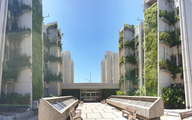
In this project, we are using precision agriculture technologies in green high-rise building walls in order to examine vertical greenery systems (VGS) as a nature-based solution for environmental problems in densely populated cities: the urban heat island, air pollution, noise, and stress. Four colleagues from Bar-Ilan, three from ARO, and one from the Hebrew University of Jerusalem are cooperating on this research. Our aims are to monitor the VGS (using thermal and hyperspectral cameras), and the environment (local climate: temperature, radiation, humidity, wind, and carbon and water fluxes), in order to assess the impact of the VGS on the ambient urban environment (and vice versa); provide health impact assessment of VGS, and explore VGS economic benefits. This project is a cooperation with Nanjing University funded by the China & Israel ministries of science and technology, and the equipment by the Israel Science Foundation (institutional equipment).
Clouds
My interest in clouds includes remote sensing of cloud microphysics using multispectral satellite data (Lensky and Rosenfeld, 1997), retrieval of precipitation formation processes in the daytime (Rosenfeld and Lensky, 1998) and nighttime (Lensky and Rosenfeld, 2003a; Lensky and Rosenfeld, 2003b), cloud aerosols interactions (Lensky and Drori, 2007), and cloud phase (Drori and Lensky, 2010).
I developed a software that uses data from the 11 spectral bands of the European geostationary satellite Meteosat Second Generation (MSG) for qualitative (RGB display) and quantitative analysis of clouds and aerosols and the interaction between them (Lensky and Rosenfeld, 2008). This tool was used to verify one of the assumptions standing at the base of the method for retrieval of precipitation formation processes (Lensky and Rosenfeld, 2006), and is also used by the training department of EUMETSAT.
Epidemiology
I use time series analysis of satellite data for research involving the epidemiology of vector-borne diseases (Morag et al. 2012; Steinman et al. 2012).
The Dead Sea.
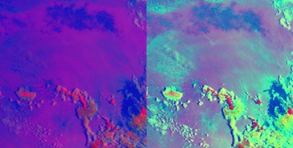
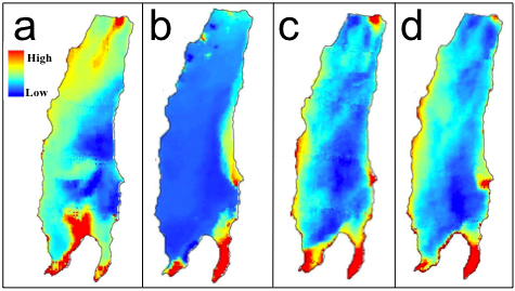
The water level of the Dead Sea is declining by more than 1 m/yr, with resulting sinkholes and deteriorated nearby infrastructure. At the same time, the level of the evaporation pond of the Dead Sea Works is rising, endangering nearby hotels. These motivated different national and international projects. My research in the Dead Sea includes the Characterization of the diurnal and seasonal cycles of the Dead Sea surface temperature (Nehorai et al. 2009). The processes occurring in the skin layer of the Dead Sea (~10 mm) (Nehorai et al. 2013).
Suspended matter in the Dead Sea: sources, transport, and dynamics. Suspended mater affects the appearance of the Dead Sea and the quality of brine pumped into evaporation ponds (Nehorai et al. 2013). These studies were conducted together with Nadav Lensky (GSI), and were funded by the World Bank: “Red Sea-Dead Sea Water Conveyance Study Program”; The Dead Sea preservation government company: “Alternative dumping sites in the Dead Sea for harvested salt from pond 5”, and the Dead Sea Works: “The expected quality of the Dead Sea brine expected to be pumped in the planned pumping station P9”.
Agriculture.
Field crops, fruit trees, and arthropods (pests in agriculture and transmitters of diseases), are sensitive to ambient temperature (Lensky and Dayan, 2011). Arthropods are sensitive to several environmental variables such as land surface temperature, vegetation, and soil moisture. I use time series of satellite data and field data to study the dynamics of pests in order to predict damage in crops (with Yafit Cohen, ARO), the transmission of disease in sheep and cattle (with Eyal Klement, HUJI). I use time series analysis of vegetation index to assess the relative contribution of perennial and annual vegetation in arid regions and the effects of grazing and tiling on soil fertility in arid regions (Helman et al, 2014). Moshe Blum in his Ph.D. (co-supervised with David Nestel, ARO), used satellite data to retrieve Olive tree canopy temperature (Blum et al. 2013) and used it as input for assessing the Olive fly population (Blum et al. 2015).
Atmospheric processes at different scales
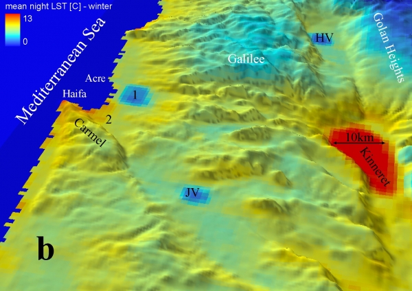
I am studying with Uri Dayan (HUJI) the factors that affect the land surface temperature in different spatial and temporal scales: Topo-climate (Lensky and Dayan, 2011), Mesoscale: sea breeze (Lensky and Dayan, 2012), and synoptic scale. Insights that emerge from this research have immediate applications in the fields mentioned above. In addition, this study may shed light on the interaction between atmospheric processes in different scales, which is one of the key factors to uncertainty regarding forecasts of climate models in the coming decades.
I also use time series analysis of satellite data to identify clouds and aerosols. So far, spectral and morphological information was used to delineate clouds. Now I develop cloud cover detection using these methods. The Israel Meteorological Service is funding a project that implements these methods for operational use.
Last Updated Date : 13/07/2022