


פרופ' איתמר לנסקי
קורות חיים
לימודים
1988-1991 BSc בפיסיקה מהאוניברסיטה העברית בירושלים (בהצטיינות)
1991-1994 MSc במדעי אטמוספרה מהאוניברסיטה העברית בירושלים (בהצטיינות יתרה)
1996-2004 PhD במדעי אטמוספרה מהאוניברסיטה העברית בירושלים
עבודה
2004-2006 מדריך דוקטור במחלקה לגיאוגרפיה וסביבה באוניברסיטת בר-אילן
2006-2011 מרצה במחלקה לגיאוגרפיה וסביבה באוניברסיטת בר-אילן
2011-2014 מרצה בכיר במחלקה לגיאוגרפיה וסביבה באוניברסיטת בר-אילן
2014 פרופ׳ חבר במחלקה לגיאוגרפיה וסביבה באוניברסיטת בר-אילן
2016-2019 ראש המחלקה לגיאוגרפיה וסביבה באוניברסיטת בר-אילן
פירסומים
65. Michael Y., G. Kozokaro, S. Brenner, and I. M. Lensky, 2022: Improving WRF-Fire Wildfire Simulation Accuracy Using SAR and Time Series of Satellite-Based Vegetation Indices. Remote Sensing, 14(12), 2941; https://doi.org/10.3390/rs14122941
64. Kayyal-Tarabeia, I., Y. Michael, I. M., Lensky, M., Blank, K., Agay-Shay, 2022: Residential greenness and site-specific cancer: A registry based cohort of 144,427 participants with a 21-years of follow-up, Tel-Aviv district, Israel. Environmental Research. doi:10.1016/j.envres.2022.113460
63. Augustinus, B. A., M. Blum, S. Citterio, R., Gentili, D., Helman, D., Nestel, U., Schaffner, H., Müller-Schärer, and I. M. Lensky, 2022: Ground-truthing predictions of a demographic model driven by land surface temperatures with a weed biocontrol cage experiment. Ecological Modeling. 446, 109897. doi:10.1016/j.ecolmodel.2022.109897
62. Liu H., H. Yin, F. Kong, A. Middel, X. Zheng, J. Huang, T sun, D. Wang, and I. M. Lensky, 2022: Change of nutrients, microorganisms, and physical properties of exposed extensive green roof substrate. Science of the Total Environment. 805, 150344. doi:10.1016/j.scitotenv.2021.150344
2021
61. Basagaña X., Y. Michael, I. M. Lensky, L. Rubin, I. Grotto, E. Vadislavsky, Y. Levi, E. Amitai, K. Agay-Shay, 2021: Identifying windows of susceptibility during pregnancy: associations between low and high ambient temperature and birthweight for 624,940 singleton term livebirths births born in Israel during 2010-2014. Environmental Health Perspectives. 129(10), doi:10.1289/EHP8117
60. Bonfil, D.J., Y. Michael, S. Shiff, I. M. Lensky, 2021: Optimizing Top Dresseing Nitrogen Fertilization Using VENμS and Sentinel-2 L1 Data. Remote Sensing. 13, 3934. https://doi.org/10.3390/rs13193934
59. Shiff S., I. M. Lensky, and D. Bonfil, 2021: Using Satellite Data to Optimize Wheat Yield and Quality under Climate Change. Remote Sensing. 13, 2049. https://doi.org/10.3390/rs13112049
58. Elbaz S., E. Sheffer, I. M. Lensky, N. Levin, 2021: The Impacts of Spatial Resolution, Viewing Angle, and Spectral Vegetation Indices on the Quantification of Woody Mediterranean Species Seasonality Using Remote Sensing. Remote Sensing. 13, 1958. https://doi.org/ 10.3390/rs13101958
57. Zheng X., F. Kong, H. Yin, A. Middel, H. Liu, D. Wang, T. Sun, I. Lensky, 2021: Outdoor thermal performance of green roofs across multiple time scales: A case study in subtropical China. Sustainable Cities and Society, doi:10.1016/j.scs.2021.102909.
56. Shiff S., D. Helman, and I. M. Lensky, 2021: Worldwide continuous gap-filled MODIS land surface temperature dataset. Scientific Data. 8:74. doi:10.1038/s41597-021-00861-7.
55. Michael Y., D. Helman, O. Glickman, D. Gabay, S. Brenner, and I. M. Lensky, 2021: Forecasting fire risk with machine learning and dynamic information derived from satellite vegetation index time-series. Science of the Total Environment. doi:10.1016/j.scitotenv.2020.142844
2020
54. Bodenheimer S., R. Nirel, I. M. Lensky, and U. Dayan, 2020: The Synoptic Skill of AOD and Angstrom Exponent Levels over the Mediterranean Basin. International Journal of Climatology. doi:10.1002/joc.6931
53. Dayan U., I. M. Lensky, B. Ziv, and Khain P., 2021: Atmospheric conditions leading to an exceptional fatal flash flood in the Negev Desert, Israel, Nat. Hazards Earth Syst. Sci., 21, 1583–1597, https://doi.org/10.5194/nhess-21-1583-2021
52. Grodek T., E. Morin, D. Helman, I. Lensky, O. Dahan, M. Seely, G. Benito, and Y. Enzel, 2020: Eco-hydrology and geomorphology of the largest floods along the hyperarid Kuiseb River, Namibia. Journal of Hydrology. 582, 124450. doi:10.1016/j.jhydrol.2019.124450
2019
51. Bodenheimer S., I. M. Lensky, and U. Dayan, 2019: Characterization of Eastern Mediterranean dust storms by area of origin; North Africa vs. Arabian Peninsula. Atmospheric Environment. 198, 158-165. doi:10.1016/j.atmosenv.2018.10.034
50. Helman D., I. M. Lensky, and D. J. Bonfil, 2019: Early prediction of wheat grain yield production from root-zone soil water content at heading using Crop RS-Met. Field Crops Research . 232,11-23. doi:10.1016/j.fcr.2018.12.003
49. Helman D., D. J. Bonfil, and I. M. Lensky, 2019: Crop RS-Met: A biophysical evapotranspiration and root-zone soil water content model for crops based on proximal sensing and meteorological data. Agricultural Water Management. 211, 210-219. doi:10.1016/J.AGWAT.2018.09.043
48. Agay-Shay K., Y. Michael, X. Basagana, E. Martinez, D. Broday, I. M. Lensky, M. Rudolf, L. Rubin, R. Kent, N. Levy, Z. Haklai, and I. Grotto. 2019: Mean and variance of greenness and pregnancy outcomes in Tel Aviv during 2000–14: longitudinal and cross-sectional approaches. International Journal of Epidemiology. 48(4) 1054-1072, https://doi.org/10.1093/ije/dyy249
2018
47. Lensky I. M., U. Dayan, and D. Helman, 2018: Synoptic circulation impact on the near surface temperature difference outweighs that of the seasonal signal in the Eastern Mediterranean. Journal of Geophysical Research-Atmospheres, 123, 11333-11347. doi:10.1029/2017JD027973
46. Michael Y., Lensky I.M., Brenner S., Tchetchik A., Tessler N., Helman D., 2018: Economic Assessment of Fire Damage to Urban Forest in the Wildland-Urban Interface Using Planet Satellites Constellation Images. Remote Sensing, 10(9), 1479. doi:10.3390/rs10091479
45. Hamdani I., Assouline S., Tanny J., Lensky I.M., Gertman I., Mor Z., Lensky N.G., 2018: Seasonal and diurnal evaporation from a deep hypersaline lake: The Dead Sea as a case study. Journal of Hydrology, 562,155-167. doi:10.1016/j.jhydrol.2018.04.057
44. Mor Z. S. Assouline, J. Tanny, I. M. Lensky, and N. G. Lensky, 2018: Effect of water surface salinity on evaporation: The case of a diluted buoyant plume over the Dead Sea. Water Resources Research. 54(3), 1460-1475. doi:10.1002/2017WR021995
43. Bodenheimer S., R. Nirel, I. M. Lensky, and U. Dayan, 2018: Relationship between AOD and synoptic circulation over the Eastern Mediterranean: A comparison between subjective and objective classifications. Atmospheric Environment. 177, 253-261. doi:10.1016/j.atmosenv.2018.01.016
42. Lensky N.G., I.M. Lensky, A. Peretz, I. Gertman, J. Tanny, S. Assouline, 2018: Diurnal course of evaporation from the Dead Sea in summer: a distinct double peak induced by solar radiation and night sea breeze. Water Resources Research. 54(1), 150-160. doi:10.1002/2017WR021536
41. Blum M., D. Nestel, Y. Cohen, E. Goldshtein, D. Helman, and I. M. Lensky, 2018: Predicting H. armigera pest population dynamics with a time-age insect population model driven by satellite data. Ecological Modelling, 369, 1-12. doi:10.1016/j.ecolmodel.2017.12.019
2017
40. Tubi A., U. Dayan, and I. M. Lensky, 2017: Moisture Transport by Tropical Plumes over the Middle East: A 30-year Climatology. Quarterly Journal of the Royal Meteorological Society, 143, 3165-3176. doi:10.1002/qj.3170
39. Weil G., I. M. Lensky, Yehezkel S. Resheff and N. Levin, 2017: Optimizing the Timing of Unmanned Aerial Vehicle Image Acquisition for Applied Mapping of Woody Vegetation Species using Feature Selection. Remote Sensing, 9, 1130; doi:10.3390/rs9111130.
38. Helman, D., Lensky, I. M., Osem, Y., Rohatyn, S., Rotenberg, E., and Yakir, D., 2017: A biophysical approach using drought stress factor for daily estimations of evapotranspiration and CO2 uptake in high-energy water-limited environments, Biogeosciences, 14, 3909-3926, https://doi.org/10.5194/bg-14-3909-2017.
37. Weil G., I. M. Lensky, and N. Levin, 2017: Using ground observations of a digital camera in the VIS-NIR range for quantifying the phenology of Mediterranean woody species. International Journal of Applied Earth Observation and Geoinformation, 62, 88-101. doi:10.1016/j.jag.2017.05.016
36. Rose J., Y. Nachum-Biala, K. Mumcuoglu, M. A. Alkhamis, A. Ben-Nun, I. Lensky, E. Klement, A. Nasereddin, Z. A. Abdeen, S. Harrus, 2017: Genetic characterization of spotted fever group rickettsiae in questing Ixodid ticks collected in Israel and environmental risk factors for their infection. Parasitology, 144(8), 1088-1101. doi:10.1017/S0031182017000336
2016
35. Helman D., Y. Osem, D. Yakir, and I. M. Lensky 2017: Relationships between climate, topography, water use and productivity in two key Mediterranean forest types with different water- use strategies. Agricultural and Forest Meteorology, 232, 319-330. doi:10.1016/j.agrformet.2016.08.018
34. Kahana-Sutin E., E. Klement, I. Lensky, and Y. Gottlieb, 2017: High relative abundance of the stable fly Stomoxys calcitrans is associated with Lumpy Skin Disease outbreaks in Israeli dairy farms. Medical and Veterinary Entomology. 31, 150-160. doi:10.1111/mve.12217
33. Helman D., I. M. Lensky, D. Yakir, and Y. Osem 2017: Forests growing under dry conditions have higher hydrological resilience to drought than do more humid forests. Glob Change Biol. 23, 2801-2817. doi:10.1111/gcb.13551.
2015
32. Helman D., I. M. Lensky, N. Tessler and Y. Osem, 2015: A phenology-based method for monitoring annual and perennial vegetation in Mediterranean forests from NDVI time series. Remote Sensing, 2015, 7(9), 12314-12335; doi:10.3390/rs7091231
31. Helman D., A. Givati, and I. M. Lensky, 2015: Annual evapotranspiration retrieved from satellite vegetation indices for the Eastern Mediterranean at 250 m spatial resolution. Atmospheric Chemistry and Physics, 15, 12567-12579. doi:10.5194/acp-15-12567-2015
30. Blum M., I. M. Lensky, P. Rempoulakis and D. Nestel, 2015: Modeling insect population fluctuations with satellite land surface temperature. Ecological Modeling. 311, 39-47. doi:10.1016/j.ecolmodel.2015.05.005
29. Ordano M., I. Engelhard, P. Rempoulakis, E. Nemny-Lavy, M. Blum, S. Yasin, I. M. Lensky, N. T. Papadopoulos, and D. Nestel, 2015: Olive fruit fly (Bactrocera oleae) population dynamics in the Eastern Mediterranean: Influence of exogenous uncertainty on a monophagous frugivorous insect. PLoS ONE 10(5): e0127798. doi:10.1371/journal. pone.0127798
28. Rotem-Mindali O., Y. Michael, D. Helman, and I. M. Lensky, 2015: The role of local land-use on the urban heat island effect of Tel Aviv as assessed from satellite remote sensing. Applied Geography, 56, 145-153. doi:10.1016/j.apgeog.2014.11.023
27. Lensky, I. M., and U. Dayan, 2015: Satellite observations of land surface temperature patterns induced by synoptic circulation. International Journal of Climatology. 35(2), 189-195. doi: 10.1002/joc.3971
26. Mussery A., S. Leu, A. Budovsky, and I. M. Lensky, 2015: Plant-Soil Interactions and Desertification: A Case Study in the Northern Negev, Israel. Arid Land Research and Management, 29(1), doi:10.1080/15324982.2014.933455
2014
25. Steinman A., Aharonson-Raz, K., S. E. Blum, A. Shnaiderman, E. Klement, I. M. Lensky, D. W. Horohov, A. E. Page, 2014: Demographic and Environmental Risk Factors for Exposure to Lawsonia intracellularis in Horses in Israel. Journal of Equine Veterinary Science, 34, 641-646. doi:10.1016/j.jevs.2013.12.003
24. Helman, D., I. M. Lensky, A. Mussery, S. Leu, 2014: Rehabilitating degraded drylands by creating woodland islets: Assessing long-term effects on aboveground productivity and soil fertility, Agricultural and Forest Meteorology, 195–196, 52-60, doi: 10.1016/j.agrformet.2014.05.003.
23. Aharonson-Raz, K., A. Rapoport, I. M. Hawari, I. M. Lensky, D. Berlin, D. Zivotofsky, E. Klement, A. Steinman, 2014: Novel description of force of infection and risk factors associated with Theileria equi in horses in Israel and in The Palestinian Authority. Ticks Tick-borne Dis., 5(4), 366-372. doi: org/10.1016/j.ttbdis.2014.01.002
22. Helman D., A. Mussery, I. M. Lensky, and S. Leu, 2014: Detecting changes in biomass productivity in a different land management regimes in drylands using satellite‐derived vegetation index. Soil Use and Management. 30, 32-39. doi: 10.1111/sum.12099
2013
21. Nehorai R., N. Lensky, S. Brenner and I. M. Lensky, 2013: The Dynamics of the Skin Temperature of the Dead Sea. Advances in Meteorology, 2013, 296714. doi:10.1155/2013/296714
20. Nehorai R., I. M. Lensky, L. Hochman, I. Gertman, S. Brenner, A. Muskin, and N. G. Lensky, 2013: Satellite Observations of Turbidity in the Dead Sea. J. Geophys. Res., 118(6), 3146–3160. doi:10.1002/jgrc.20204
19. Blum, M., I. M. Lensky, and D. Nestel, 2013: Estimation of olive grove canopy temperature from MODIS thermal imagery is more accurate than interpolation from meteorological stations. Agricultural and Forest Meteorology, 176, 90-93. doi:10.1016/j.agrformet.2013.03.007
18. Mussery, A., S. Leu, I. Lensky and A. Budovsky, 2013: The Effect of Planting Techniques on Arid Ecosystems in the Northern Negev. Arid Land Research and Management, 27, 90-100. doi:10.1080/15324982.2012.719574
2012
17. Morag, N., E. Klement, Y. Saroya, I. M. Lensky, and Y. Gottlieb, 2012: Prevalence of the symbiont Cardinium in Culicoides (Diptera: Ceratopogonidae) vector species is associated with land surface temperature. FASEB Journal fj.12-210419; doi:10.1096/fj.12-210419
16. Goldstein E., Y. Cohen, A. Hetzroni, I. M. Lensky, U. Zig, and L. Tsror (Lahkim), 2012: A knowledge-based prediction model of Verticillium dahliae and its use for rational crop rotation. Computers and Electronics in Agriculture, 85, 112-122. doi: 10.1016/j.compag.2012.02.011
15. Steinman A., T. Zimmerman, E. Klement, I. M. Lensky, D. Berlin, Y. Gottlieb, G. Baneth, 2012: Demographic and environmental risk factors for infection by Theileria equi in 590 horses in Israel. Veterinary Parasitology, 187, 558-562. doi:10.1016/j.vetpar.2012.01.018
14. Lensky, I. M., and U. Dayan, 2012: Continuous detection and characterization of the sea breeze in clear sky conditions using Meteosat Second Generation. Atmos. Chem. Phys., 12, 6505–6513. doi:10.5194/acp-12-6505-2012
2011 -
13. Lensky, I. M., and U. Dayan, 2011: Detection of fine-scale climatic features from satellites and possible implications for Agricultural Planning. Bull. Amer. Meteor. Soc., 92, 1131-1136. doi:10.1175/2011BAMS3160.1
12. Drori, R., and I. M. Lensky, 2010: Monitoring the evolution of cloud phase profile using MSG data, Atmospheric Research, 97, 577-582. doi:10.1016/j.atmosres.2010.05.009.
11. Nehorai, R., I. M. Lensky, N. G. Lensky, and S. Shiff 2009: Remote sensing of the Dead Sea surface temperature. J. Geophys. Res., 114, C05021, doi:10.1029/2008JC005196.
10. Lensky, I. M., and D. Rosenfeld, 2008: Clouds-Aerosols-Precipitation Satellite Analysis Tool (CAPSAT). Atmos. Chem. Phys., 8, 6739-6753. doi:10.5194/acp-8-6739-2008
9. Lensky, I. M., and V. Levizzani, 2008: Estimation of precipitation from space based platforms. In: Precipitation: Advances in measurement, estimation and prediction. S. Michaelides, Ed., Springer, 193-216. doi:10.1007/978-3-540-77655-0_8
8. Lensky, I. M., and S. Shiff, 2007: Using MSG to monitor the evolution of severe convective storms over East Mediterranean sea and Israel, and its response to aerosol loading. Adv. Geosci., 12, 95–100.
7. Lensky, I. M., and R. Drori, 2007: A Satellite-Based Parameter to Monitor the Aerosol Impact on Convective Clouds. J. Appl. Meteor. & Clim., 45, 660-666. doi:10.1175/JAM2487.1
6. Rosenfeld, D., I. M. Lensky, J. Peterson, and A. Gingis, 2006: Potential impacts of air pollution aerosols on precipitation in Australia. Clean Air and Environmental Quality, 41, 43-49.
5. Lensky, I. M., and D. Rosenfeld, 2006: The time-space exchangeability of satellite retrieved relations between cloud top temperature and particle effective radius Atmos. Chem. Phys., 6, 2887-2894.
4. Lensky, I. M., and D. Rosenfeld, 2003: A night rain delineation algorithm for infrared satellite data based on microphysical considerations. J. Appl. Meteor. 42, 1218-1226. doi:10.1175/1520-0450(2003)042<1218:ANDAFI>2.0.CO;2
3. Lensky, I. M., and D. Rosenfeld, 2003: Satellite-based insights into precipitation formation processes in continental and maritime convective clouds at nighttime. J. Appl. Meteor, 42, 1227-1233.
2. Rosenfeld, D., and I. M. Lensky, 1998: Satellite-based insights into precipitation formation processes in continental and maritime convective clouds. Bull. Amer. Meteor. Soc., 79, 2457-2476.
1. Lensky, I. M., and D. Rosenfeld, 1997: Estimation of precipitation area and rain intensity based on the microphysical properties retrieved from NOAA AVHRR data. J. Appl. Meteor., 36, 234-242.
מחקר
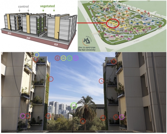
על רקע תהליכי עיור מואצים בארץ ובעולם, לתופעות של הצטופפות אוכלוסייה בעיר, בנייה לגובה והתמעטות שטחים פתוחים בעיר השלכות שליליות על האדם והסביבה. מרחב הפתרונות המועדף לבעיות הנובעות מתהליכים אלו נמצא בתחום הפתרונות מהטבע (nature based solutions). לצמחיה יתרונות רבים לטיוב סביבת האדם: השפעה על טמפרטורת הסביבה, איכות אוויר, רעש, סטרס. לאור התמעטות השטח בעיר לגידול צמחיה, מוצע פתרון של גידול צמחיה על קירות, פתרון הדורש טכנולוגיות מתקדמות. במסגרת מחקר קירות ירוקים הגדול בהיקפו כיום בעולם הוקמו באוניברסיטת בר אילן שני קירות ירוקים (צמחיה) ומערך ניטור סביבתי על שני בניינים ועל זוג בניינים זהים (ביקורת). המחקר בוחן את ההשפעה ההדדית של קירות ירוקים על הסביבה העירונית במונחים של טמפרטורה, לחות, קרינה (ארוכת וקצרת גל), קיבוע פחמן, ורעש לאורך עונות השנה ובתנאי מזג אוויר משתנים. כמו כן נבחנת בעזרת שיטות של חקלאות מדייקת (ובדיקות של הצמח) השפעת הסביבה על הצמחייה. השפעת הקירות הירוקים על סביבת האדם תתורגם להשפעה על בריאות הציבור כולל על מדדים שונים של רווחת הפרט, כגון שביעות רצון ורווחה (wellbeing). ניתוח כלכלי סביבתי יכמת את ההשפעות הנ״ל במונחים כספיים. למרות שפתרונות מהטבע מוצעים היום בספרות המחקרית כפתרון מועדף לבעיות סביבתיות / בריאותיות, עוד לא נערך מחקר מקיף בנושא. המחקר ממומן ע״י משרד המדע (וציוד מ ISF). בצוות המחקר מומחים מתחומי ה: סביבה (איתמר לנסקי, דוד הלמן), הנדסה חקלאית (יפית כהן, ויקטור אלחנתי), פיזיולוגיה של הצמח (נירית ברנשטיין), מדעי הרפואה (קרן אגאי-שי), רווחה (עמית שרירא), כלכלה סביבתית (ענת צ׳צ׳יק), תכנון (שלומית פלינט), ומנהל עסקים (איל יניב). לכתבה ב The Times of Israel
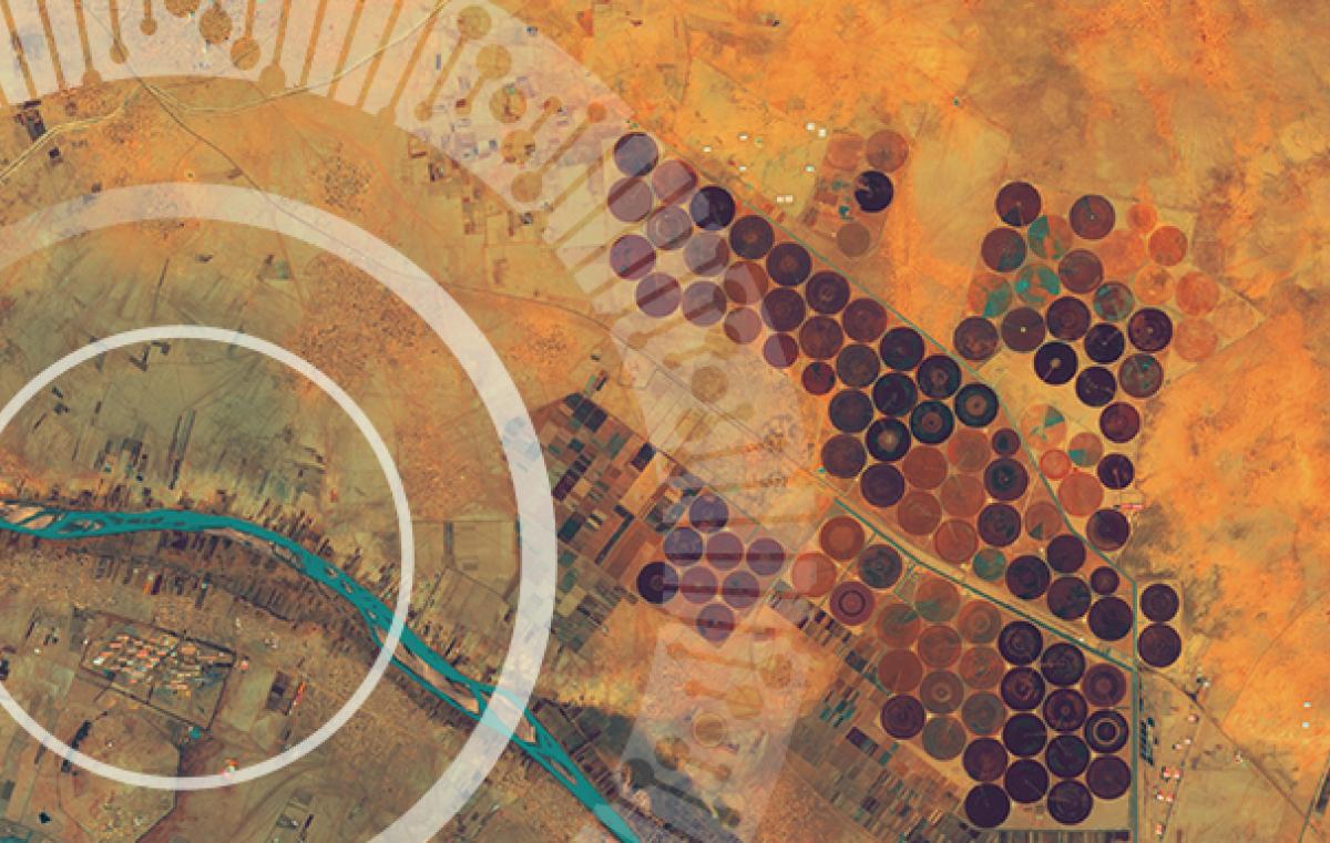
לגדל חיטה בעזרת לוויין - חוקרים פיתחו כלי המשתמש בנתוני טמפרטורת קרקע שנאספו על-ידי לוויין לשיפור יבולים
שינוי האקלים וצמצום שטחי החקלאות מצד אחד וגידול האוכלוסייה מצד שני מגבירים את הצורך בהפקת המרב משטחי החקלאות הקיימים. מתוך ההבנה שגם בין שדות סמוכים יש שונות מיקרו-אקלימית, ולאור הידע האגרונומי על התנאים המיטביים הנדרשים עבור זני חיטה שונים, מחקר חדש רותם נתוני לוויין כדי לעזור לחקלאים ליצור את ההתאמה הטובה ביותר בין זני החיטה שהם מגדלים, תזמון הזריעה והחלקה המיועדת.
גידולי החיטה משמעותיים מאוד בישראל ומשתרעים על שטחים של כמיליון דונם. הם כוללים זנים רבים, הנבדלים זה מזה בכושר ייצור יבול גרגרים ואיכותו. תנאי הגידול משפיעים מאוד הן על הייצרנות והן על האיכות של כל זן. באמצעות יישום שפיתחו שילה שיף (כפרק בדוקטורט) ופרופ' איתמר לנסקי מהמחלקה לגיאוגרפיה וסביבה באוניברסיטת בר-אילן, וד"ר דוד בונפיל ממכון וולקני, חקלאים יוכלו לשחק עם הגורמים שבשליטתם כדי לחמוק עד כמה שניתן מעקה אקלימית ולהגיע ליבולים טובים ואיכותיים יותר.
תנאים אקלימיים שונים במהלך תקופת הבשלת הגרעין הם גורם מרכזי המשפיע על יבול החיטה ואיכותו. הגורם לשונות המרחבית האקלימית הוא בעיקר הטופוגרפיה וכיסוי הקרקע בסביבת השדה. גידולי החיטה באזורים יובשניים למחצה, הנפוצים בישראל, מתמודדים עם טמפרטורות גבוהות ועם העקה שהן גורמות בתקופת ההבשלה. המחקר, שפורסם בכתב העת המדעי Remote Sensing, קובע שניתן להיעזר בחישה מרחוק – כלומר בנתוני לוויין - כדי לנטר הן את התפתחות הגידול והן את טמפרטורות הקרקע. החוקרים פיתחו כלי למיטוב ניהול השדה בהיבט של בחירת זן החיטה ותזמון הזריעה.
לצורך המחקר נותחו נתונים מ-155 מחקרי זנים שבוצעו בישראל. הנתונים מציגים תנאי סביבה שונים המגלים כמה "ימי מעלה" נדרשים עבור כל זן חיטה אביבי ישראלי. "ימי מעלה", כלומר כמה מעלות (מעל ערך סף מסוים) נצברות בכל יום, הוא מדד מקובל להתפתחות במקרים אלה. לכל זן חיטה נדרש מספר שונה של ימי מעלה כדי להתפתח משלב הנביטה לשלב יצירת השיבולת.
החוקרים פיתחו יישום Engine Google Earth (GEE) לניתוח מרחבי של טמפרטורת הקרקע. באמצעות שינוי זן החיטה ו/או יום הנביטה ביישום, החקלאי יכול לחשוף כל שדה חיטה לתנאים אקלימיים שונים במהלך תקופת הבשלת השיבולים. הכלי מאפשר לחקלאים להעריך מראש את מועד ההשתבלות הצפוי וכך לבחור עבור כל השדה את הזן המתאים ואת תאריך הזריעה כדי להקטין את הסיכויים שהחיטה תהיה חשופה לגלי חום ובשל כך לפגיעה ביבול.
עם שינוי האקלים שאנו חווים מדי יום, ניתן להשתמש ביישום כדי להעריך גם את השפעתם של תרחישי שינוי אקלים גלובליים בעתיד ולתכנן בהתאם אסטרטגיות טיפוח עתידי בישראל והסתגלות גם באזורים אחרים.
מחקר קודם, שממצאיו היו חלק מהתשתית ליצירת יישום GEE עבור החקלאים, בוצע אף הוא על ידי שיף ולנסקי, הפעם עם ד"ר דוד הלמן מהאוניברסיטה העברית. מטרת המחקר הייתה יצירת סדרות זמן רציפות של נתוני לוויין למטרות כמו אלה המתוארות לעיל למיטוב גידול החיטה. החוקרים השלימו נתוני טמפרטורה חסרים (בעיקר בגלל עננות) בעזרת שילוב של תצפיות מלוויינים ונתונים ממודל חיזוי מזג אוויר. המידע שהתקבל מתצפיות השתבלות זני חיטה באזורי גידול שונים בישראל ועל ידי צופים שונים אימתו מודל זה בהצלחה.
שימושים נוספים בחקלאות לסדרות זמן של טמפרטורת פני השטח הם חיזויי יבול בגידולי שדה שונים מעבר לחיטה, חיזוי התפתחות מזיקים לשם קביעת אסטרטגיות בתחום הגנת הצומח, חיזוי ״מנות קור״ הנחוצות לעצי פרי נשירים. בעצם, כמעט כל אספקט אגרונומי מושפע מטמפרטורה, לכן לפיתוח זה פוטנציאל רב בכיווני יישום נוספים הדורשים מחקר נוסף
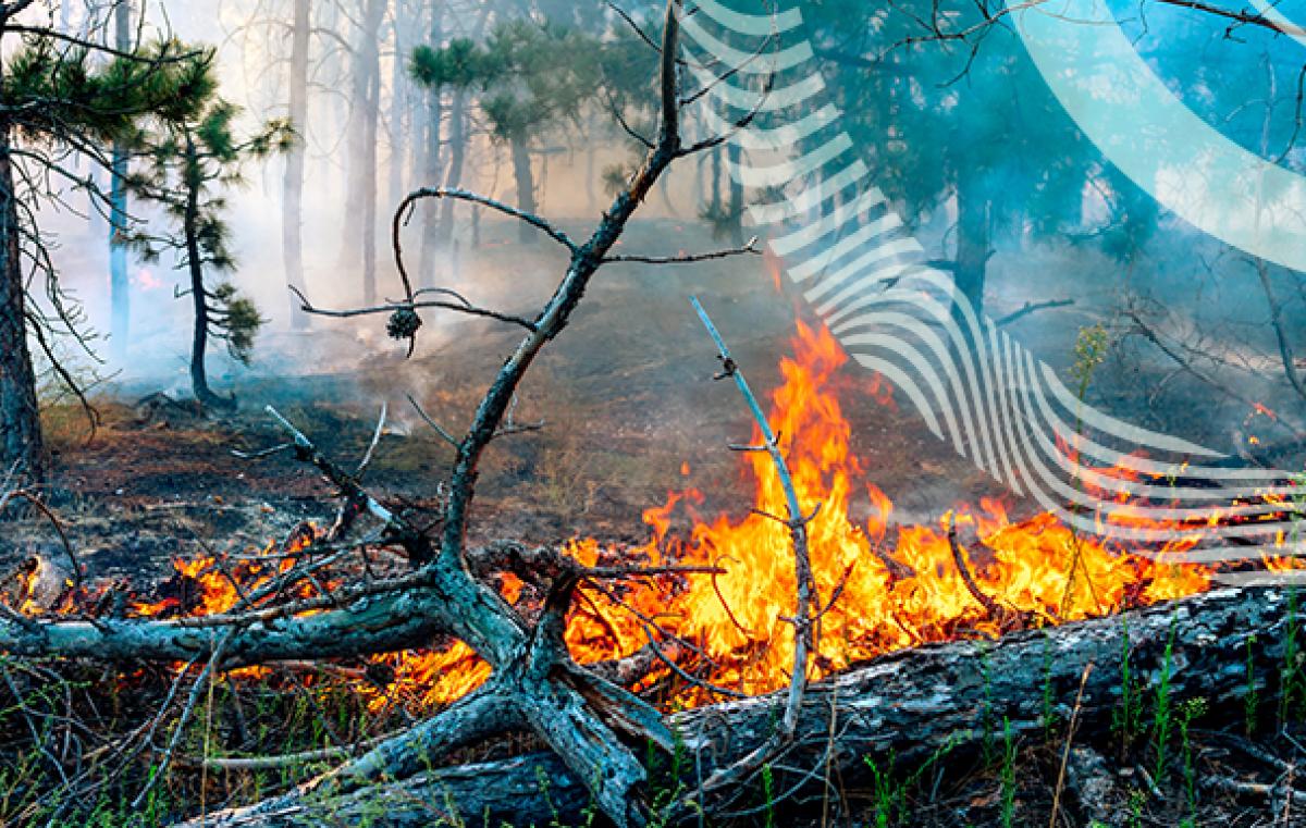
בינה מלאכותית ליצירת מפות סיכון מפני שריפותבינה מלאכותית ליצירת מפות סיכון מפני שריפות
מיפוי האזורים המועדים לסכנת שריפות חשוב הן למניעת שריפות והן לכיבוין לאחר שהן פורצות. רוב המפות לחיזוי שריפות מיוצרות באמצעות שימוש בנתונים סטטיים של משתנים כמו טופוגרפיה, צפיפות צמחייה ולחות. לעתים קרובות דולים את האינפורמציה הזאת מלוויינים. אולם, דינמיקות צומח ארוכות טווח והיובש המצטבר בצמחייה מעוצה, שהם גורמים העשויים להשפיע על התלקחות ועל התפשטות אש, נכללים רק לעתים נדירות במפות של אזורי סיכון לשריפות. במעבדה של פרופ' איתמר לנסקי מהמחלקה לגאוגרפיה וסביבה, חוקרים את השפעתם של שני מדדים, שהאינפורמציה לגביהם נשאבת מהלוויין והם מציגים דינמיקות ארוכות טווח של הצומח, על מפות סיכון שריפות. מדד אחד מבטא את צפיפות הצומח המעוצה בתא שטח והמדד השני מבטא את מגמת היובש בצומח המעוצה בטווח של חמש שנים.
החוקרים בחנו האם שני המדדים משפרים את איכות מפת סיכוני השריפות באמצעות שלושה אלגוריתמים של למידת מכונה (Logistic Regression, Random Forest, XGBoost) והשתמשו בשריפות היער שאירעו ביוון ב-2007 לביצוע הניתוח. התוצאות מראות כי אלגוריתם XGBoost, שמטפל באינטראקציות בין משתנים ואפקטים לא-ליניאריים, היה מודל למידת המכונה שהניב את התוצאות הטובות ביותר. מדד צפיפות הצומח המעוצה שיפר את ביצועי המודל בעוד שהאפקט של יובש ארוך טווח בעל משמעות רק במקומות שבהם יש צמחייה מעוצה צפופה. השיטה המוצעת עשויה לייצר מפות סיכוני שריפות מדויקות יותר בהשוואה לשיטות המיפוי הקונבנציונליות ולספק אינפורמציה חשובה על דינמיקת הצומח שתשמש למודלים של חיזוי התנהגות שריפות יער. המחקר הוא חלק מעבודת הדוקטורט של ירון מיכאל, והשתתפו בו ד״ר דוד הלמן, ד״ר אורן גליקמן, דוד גבאי, פרופ׳ שלמה (סטיב) ברנר ופרופ׳ איתמר לנסקי.
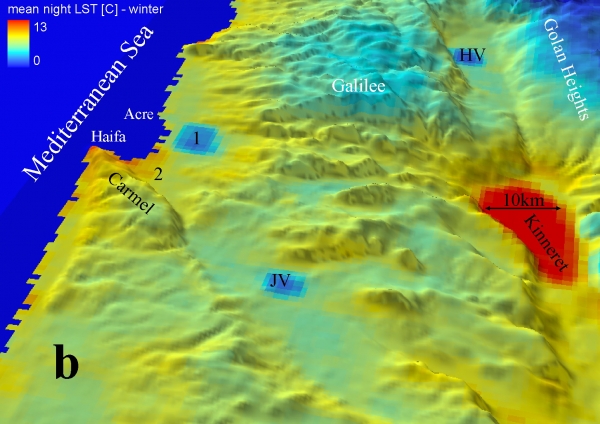
חישה מרחוק של פני ים המלח.
גורלו של ים המלח עלה לכותרות עקב ירידת המפלס של כמטר בשנה ובעקבות כך תופעת הבולענים והרס התשתיות בסביבות ים המלח, ובשל בעיית עלית מפלס בריכות האידוי של מפעלי ים המלח המסכנים את המלונות בסביבה. אני עוסק בחישה מרחוק של פני ים המלח לצורך:
(א) אפיון המחזור היממתי והעונתי של טמפרטורת שכבת הגבול של ים המלח.
(ב) הבנה של התהליכים המתרחשים בשכבת גבול של כ 10 מיקרון בפני ים המלח.
(ג) מעקב אחר חומר מרחף כדי להבין את המקורות, מנגנוני ההסעה והדינאמיקה של חומר מרחף. לחומר המרחף השפעה על המראה של ים המלח ועל איכות התמלחת הנשאבת לבריכות האידוי.
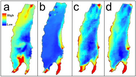
עבודות אלה נעשות ע"י רוני נהוראי במסגרת דוקטוראט וליאור הוכמן במסגרת מוסמך בהנחיה משותפת עם ד"ר נדב לנסקי מהמכון הגיאולוגי.
חישה מרחוק בחקלאות.
גידולי שדה, עצי פרי, ופרוקי רגלים (מזיקים בחקלאות ומעבירי מחלות בבעלי חיים ובאדם), רגישים לטמפרטורת הסביבה. אוכלוסיות של פרוקי רגליים שונים רגישות מאוד למספר משתנים סביבתיים כגון טמפרטורת קרקע, צמחיה, לחות קרקע וכדומה. בעזרת ניתוח סדרות זמן של משתנים אלה המתקבל מלוויינם ובשילוב עם נתוני לכידות אנו לומדים על הדינאמיקה של אוכלוסיות אלה. שימוש במערכת זו נעשה לצורך חיזוי מזיקים בגידולי שדה, העברת מחלות בצאן ובקר, ובחקר שכיחות מחלת לישמניאזיס עורית (שושנת יריחו) בקרב חיילים המשרתים בפיקוד דרום. עבודות אלה נעשות בשיתוף עם פרופ' איל קלמנט מהאוניברסיטה העברית וד"ר יפית כהן מהמנהל החקלאי של משרד החקלאות.
אני משתמש בניתוח סדרות זמן של אינדקס צמחיה להעריך את התרומה היחסית של צמחיה רב שנתית, עשבוניים וקרומי קרקע באזורים צחיחים. בעזרת כלים אלה אני גם בודק את ההשפעה של רעיית-יתר, חרישה ורעיה מבוקרת על פוריות הקרקע באזורים צחיחים, ובעזרת תובנות אלו אני מכין מודל לשימוש בר-קיימא של מרעה באזורים אלו.
משה בלום חוקר את הדינמיקה של אוכלוסית זבוב הזית והליותיס בדוקטוראט בהנחיה משותפת עם ד"ר דוד נסטל.
שינויים האקלימיים, הנגרמים בעיקר בעקבות תופעת ההתחממות הגלובלית צפויים לפגוע קשות ברווחת האדם ככלל וביצור התוצרת החקלאית בפרט. בשנים האחרונות אנו עדים להחמרה בתנאי הסביבה, שלהם השפעה ישירה על כושר היצור של הגידולים החקלאיים ואיכות התוצרת. שכיחות בצורות, שינוי פרופיל עונת הגשמים, כמו גם שינוי פרופיל הטמפרטורה של עונות הגידול בישראל הם חלק מתהליכים עולמיים כלליים. גידולי דגנים בארץ ובעיקר גידול החיטה חשוף למזג האוויר ההפכפך באזור הים התיכון (כמויות משקעים נמוכות ולא סדירות וגלי חום) אשר משפיע על איכות החיטה לאפיה. הסביבה החקלאית הזו מצריכה מחקר ויצור אמצעים אשר יקנו לחקלאים יציבות בייצור חיטה ואיכותה ואשר ישפרו את יכולת הגידול להתמודד עם עקות סביבה. אני שותף במיזם החיטה הישראלית שמרכז ד״ר דוד בונפיל ומתמודד עם אתגרים אלה.
חישה מרחוק של תהליכים אטמוספריים בסקאלות שונות
אני חוקר את הגורמים המשפיעים על טמפרטורת הקרקע בסקאלות זמן ומרחב שונות: טופו-אקלים, בריזת הים, והסקאלה הסינופטית. לתובנות העולות ממחקר זה ישנם יישומים מידיים בחלק גדול מהתחומים שהוזכרו לעיל. בנוסף, מחקר זה עשוי לשפוך אור על האינטראקציה שבין התהליכים האטמוספריים בסקאלות השונות, שהוא אחד הגורמים המרכזיים לאי ודאות לגבי תחזיות של מודלים אקלימיים לעשורים הקרובים. עבודה זו נעשית בשיתוף עם פרופ' אורי דיין מהאוניברסיטה העברית.
חישה מרחוק של עננים
אני עוסק בחישה מרחוק מלוויינים רב ערוציים של מיקרופיסיקה של עננים, בדגש על הפאזה ועל האינטראקציה עם אירוסולים, וחילוץ תהליכי יצירת משקעים ביום ובלילה.
פיתחתי תוכנה שמנצלת את המידע הרב ערוצי המתקבל מהלוויין האירופאי העומד Meteosat Second Generation לניתוחים איכותיים וכמותיים של תכונות עננים ואירוסולים והאינטראקציה בינם.
בעזרת ניתוח סדרות זמן של מידע מלוויינים, ניתן לזהות עננים ואירוסולים המהווים "הפרעה" ביחס לתכונות הקרקע שנצפה לקבל בלוויין. תיחום האזורים המכוסים בעננים נחוץ לכל ניתוח של תכונות קרקע מלוויינים. עד כה השתמשו במידע ספקטרלי ומורפולוגי כדי לקבוע אם יש ענן בפיקסל מסוים. שימוש בסדרות זמן מאפשר זיהוי של עננים שלא מכסים את כל הפיקסל ו/או עננים דקים. עבודה זו היא חלק מהדוקטוראט של שילה שיף, ותוכנה המבוססת על עקרונות אלו ופותחה ע"י שילה שיף משמשת את השירות המטאורולוגי לצרכים שלהם.
אסון נחל צפית כביטוי קיצוני לסופות גשם בנגב אורי דיין, ברוך זיו, איתמר לנסקי, פבל חיין - מאמר באקולוגיה וסביבה
אמצעי התקשורת
תאריך עדכון אחרון : 13/07/2022